Skip to main content
Collections
People
Sites
Related publications
Historic events
Thesaurus
Advanced Search
Currently indexing
Advanced Search Objects: results
Close
Refine Results
Artist / Maker / Culture
Hydrographic Office of the Admiralty
(12)
Hydrographic Department of the Admiralty
(4)
Hydrographic Service, RAN
(2)
Nathaniel Bowditch
(1)
Classification(s)
Ephemera
(41)
Maps, charts and plans
(28)
Books and journals
(1)
Date
to
Collection focus areas
Shipping, Trade and Industry
(45)
Australian Naval History
(12)
Travel, Tourism, Sport and Leisure
(12)
Australian - American Maritime Relations
(1)
Image Available
Sort:
Relevance
Title (A–Z)
Date (Older First)
Object number (Ascending)
Primary Maker (A-Z)
Last Updated (Ascending)
List
Images
Table
Advanced Search
Filters
View PDF
Title
Artist / Maker / Culture
Object number
Description
Date Range
to
Collection focus areas
All
Australian - American Maritime Relations
Australian Naval History
Environment
Exploration and Colonisation
Fleet Services
Immigration
Indigenous Communities
Maritime Archaeology
Maritime Technology
Shipping, Trade and Industry
Travel, Tourism, Sport and Leisure
Classification(s)
All
(not assigned)
Animals and animal products
Armament
Art
Audio visual material
Books and journals
Born digital media
Ceremonial artefact
Clothing and personal items
Coins and medals
Commemorative artefacts
Decorative and folk art
Ephemera
Exhibition
Geological specimen
Maps, charts and plans
Models
Photographs
Posters and postcards
Sound communication
Tableware and furnishings
Tools and equipment
Toys, games and souvenirs
Vessels and fittings
Visual communication
In Collection(s)
All
Blueback (2022) Collection
For sickness and health - medicine in the collection
Freshwater Ponds
Gapu-Monuk ~ Saltwater
Graeme Andrews
Manuscript diaries, journals and logs
Model ships
Music
Navigators and Explorers
New to the collection
Ocean Science & Sustainability
Recently digitised
Sea the world
Sharks
Ship portraits
Shipwrecked: Artefacts from the BATAVIA and Dutch shipwrecks off Western Australia
Staff favourites
Stories in photographs
TỰ DO Vietnamese refugee boat
Under Southern Skies - navigation and voyaging
Valerie Taylor
Whaling
Thesaurus
Thesaurus
Show only matches
There are no search results!
Image Available
Bibliography
Clear
70 for
Thesaurus
:
nautical charts
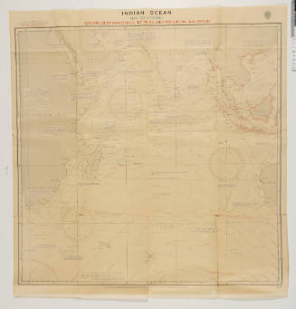
Navigation chart for the Indian Ocean May to October
Hydrographic Department of the Admiralty
1940s
Image Not Available
for Collection of nautical charts and plans of Australia
Collection of nautical charts and plans of Australia
1865 - 1976
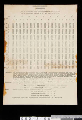
Admiralty charts and table of courses
1944
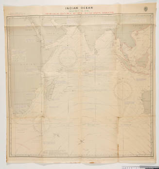
Navigation chart of Indian Ocean November to April
Hydrographic Department of the Admiralty
1942
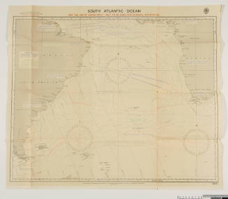
Navigation chart for the South Atlantic Ocean
Hydrographic Department of the Admiralty
1942
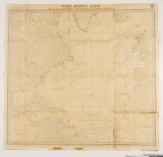
Navigation chart for the North Atlantic Ocean
Hydrographic Department of the Admiralty
1942
Banka Strait region used on KRAIT
Hydrographic Office of the Admiralty
1942
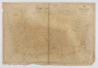
Malacca Strait used by KRAIT personnel
Hydrographic Office of the Admiralty
1942
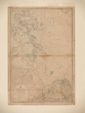
China Sea and Banka Strait used by KRAIT personnel
Hydrographic Office of the Admiralty
1942
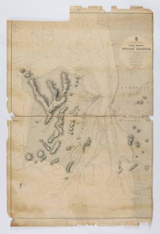
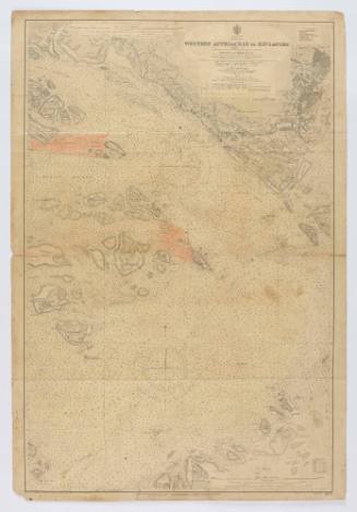
Western approaches to Singapore used by KRAIT personnel
Hydrographic Office of the Admiralty
1942
Singapore Strait used by KRAIT personnel
Hydrographic Office of the Admiralty
1942
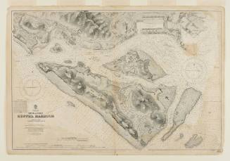
China Sea, Singapore and Keppel Harbour used by KRAIT personnel
Hydrographic Office of the Admiralty
1942
Image Not Available
for Nautical Chart, Fremantle Harbour and Gage Roads
Nautical Chart, Fremantle Harbour and Gage Roads
1865 - 1976
Image Not Available
for Nautical Chart, Bass Strait
Nautical Chart, Bass Strait
1865 - 1976
Image Not Available
for Nautical Chart, Bass Strait - Western Sheet
Nautical Chart, Bass Strait - Western Sheet
1865 - 1976
Image Not Available
for Nautical Chart, North Point to Stony Head including River Tamar
Nautical Chart, North Point to Stony Head including River Tamar
1865 - 1976
Image Not Available
for Nautical Chart, Montagu Island to Beecroft Head
Nautical Chart, Montagu Island to Beecroft Head
1865 - 1976
Image Not Available
for Nautical Chart, Jervis Bay to Port Jackson
Nautical Chart, Jervis Bay to Port Jackson
1865 - 1976
Image Not Available
for Nautical Chart, Jervis Bay to Port Jackson
Nautical Chart, Jervis Bay to Port Jackson
1865 - 1976
Image Not Available
for Nautical Chart, Port Jackson to Port Stephens
Nautical Chart, Port Jackson to Port Stephens
1865 - 1976
Image Not Available
for Nautical Chart, Port Stephens to Tacking Point
Nautical Chart, Port Stephens to Tacking Point
1865 - 1976
Image Not Available
for Nautical Chart, Tacking Point to Coffs Islands
Nautical Chart, Tacking Point to Coffs Islands
1865 - 1976
Image Not Available
for Nautical Chart, Moreton Bay, Approaches to Brisbane
Nautical Chart, Moreton Bay, Approaches to Brisbane
1865 - 1976
Image Not Available
for Nautical Chart, Brisbane River
Nautical Chart, Brisbane River
1865 - 1976
Next Page